Physical Geography
Physical geography studies the natural features and processes that shape Earth's surface — from towering mountain ranges built by tectonic forces to river valleys carved by erosion over millions of years.
This guide covers Earth's internal structure, plate tectonics, weathering and erosion, the water cycle, world biomes, and geographic tools — plus an interactive biomes map and practice quiz.
1Introduction
Physical geography explores the connections between the lithosphere (land), atmosphere (air), hydrosphere (water), and biosphere (life), revealing how they interact to create the diverse landscapes and environments we see around us.
Why it matters: Understanding physical geography helps us comprehend natural disasters (earthquakes, volcanoes, floods), the distribution of vital resources (water, fertile soil), and the dynamics of environmental change (climate change, desertification).
Earth is a truly dynamic planet — its surface is constantly being built up by powerful tectonic forces from within and worn down by weathering and erosion from without.
Imagine standing at the edge of the Grand Canyon — the countless layers of rock beneath your feet tell a story of billions of years of Earth's history, meticulously carved by the persistent force of the Colorado River.
2Key Definitions
Study of Earth's natural features — landforms, climate, water, ecosystems
The rigid outer layer of Earth (crust + upper mantle)
Theory that Earth's crust is divided into moving plates
Plates collide — mountains, subduction, volcanoes
Plates separate — mid-ocean ridges, rift valleys
Plates slide past each other — earthquakes
One plate slides beneath another into the mantle
Pacific rim zone with 75% of active volcanoes, 90% of earthquakes
Breaking down rocks in place (mechanical, chemical, biological)
Transporting weathered material by water, wind, ice, gravity
Eroded material is laid down in a new location
Large moving body of dense ice that erodes and deposits
Continuous movement of water: evaporation → condensation → precipitation → runoff
Underground layer of rock/gravel that holds extractable groundwater
Area of land that drains into a common body of water
Large region with specific climate, plants, and animals
Community of organisms interacting with their environment
Line on a topographic map connecting points of equal elevation
Deflection of moving objects on a rotating Earth
Climate = long-term patterns; Weather = short-term conditions
3Earth's Structure & Plate Tectonics
Earth's Layers
Our planet is composed of concentric layers, each with distinct properties:
Earth's Internal Structure
Click a layer on the diagram or the labels to explore its properties
Click a layer on the diagram or a button above to see details
Continental Drift & Evidence
Alfred Wegener proposed that continents slowly move over Earth's surface. His evidence included matching fossils across continents, the jigsaw-like fit of coastlines (South America and Africa), matching rock types and mountain ranges, and paleoclimate evidence.
Plate Boundaries
The interactions between tectonic plates at their boundaries create most of Earth's major geological features:
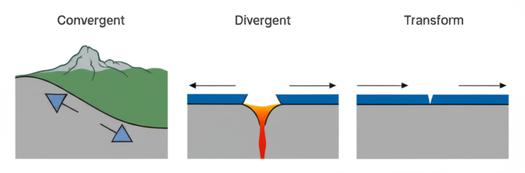
Convergent (Colliding)
- Oceanic-Continental: Oceanic plate subducts beneath continental — deep trenches, volcanic mountains (Andes, Cascades)
- Oceanic-Oceanic: One oceanic plate subducts — deep trenches, volcanic island arcs (Japan, Mariana Trench)
- Continental-Continental: Both crumple upward — massive non-volcanic mountains (Himalayas, Alps)
Divergent (Separating)
- Mid-Ocean Ridges: Magma rises and creates new oceanic crust (Mid-Atlantic Ridge)
- Rift Valleys: Continental crust pulling apart (East African Rift Valley)
Transform (Sliding Past)
Plates slide horizontally past each other, generating friction and earthquakes. No crust is created or destroyed. Example: San Andreas Fault in California.
Volcanoes
Shield
Broad, gentle slopes. Fluid lava flows. (Hawaiian volcanoes)
Composite (Strato)
Tall, steep, explosive. Lava + ash layers. (Mt. Fuji, Mt. St. Helens)
Cinder Cone
Smallest, simplest. Ejected lava fragments around vent.
Earthquakes
Caused by the release of energy from tectonic plate movement. Key terms:
- Focus: Point beneath the surface where the earthquake originates
- Epicenter: Point on the surface directly above the focus
- Seismic Waves: Energy waves that travel outward (P-waves, S-waves, surface waves)
- Richter Scale: Logarithmic scale — each whole number = 10x more amplitude, ~32x more energy
4Weathering, Erosion & Deposition
These three processes work together to constantly reshape Earth's surface, breaking down existing landforms and building new ones.
Types of Weathering
Mechanical (Physical) Weathering
Breaks rocks into smaller pieces without changing chemical composition.
- Frost wedging: Water freezes in cracks, expands, pries rock apart
- Root growth: Plant roots grow into cracks, widening them
- Thermal expansion: Heating and cooling causes fracturing
- Abrasion: Rocks grind against each other (carried by wind/water)
Chemical Weathering
Changes the chemical composition of rocks.
- Acid rain: Dissolves certain minerals (especially limestone)
- Oxidation: Iron-rich minerals react with oxygen → rust
- Carbonation: CO₂ in water forms carbonic acid → dissolves limestone (creates caves)
Biological Weathering
Caused by living organisms — plant roots, burrowing animals, lichens breaking down rock surfaces.
Agents of Erosion
Rivers, streams, rainfall, waves — the most powerful agent globally
Carries sand and dust, especially effective in dry regions
Massive ice sheets scrape and carry enormous amounts of rock
Causes landslides, rockfalls, mudslides (mass wasting)
Landforms Created
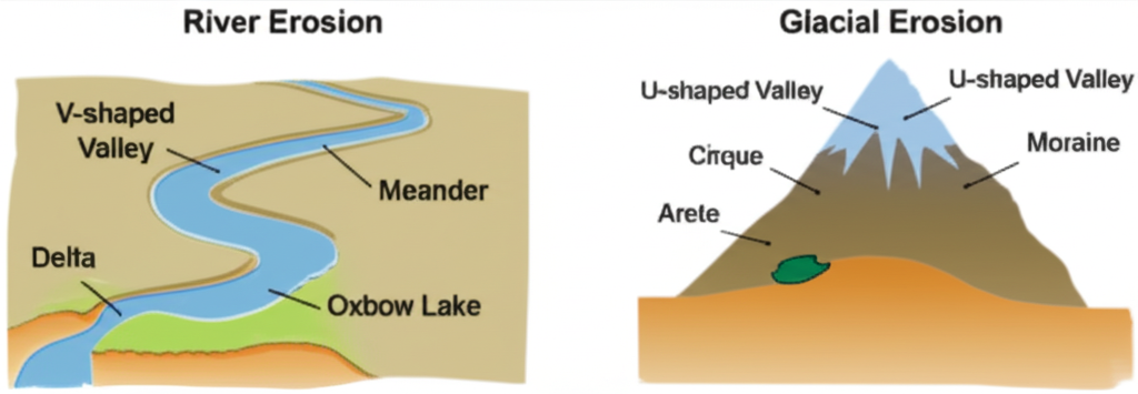
River Erosion Creates:
- V-shaped valleys
- Meanders (winding curves)
- Oxbow lakes (cut-off meanders)
- Deltas (sediment at river mouth)
- Canyons, waterfalls, gorges
Glacial Erosion Creates:
- U-shaped valleys
- Cirques (bowl-shaped depressions)
- Arêtes (sharp knife-edge ridges)
- Horns (pyramid peaks, e.g., Matterhorn)
- Moraines, drumlins, erratics
5The Water Cycle & Water Systems
The water cycle (hydrologic cycle) describes the continuous movement of water on, above, and below the surface of Earth.
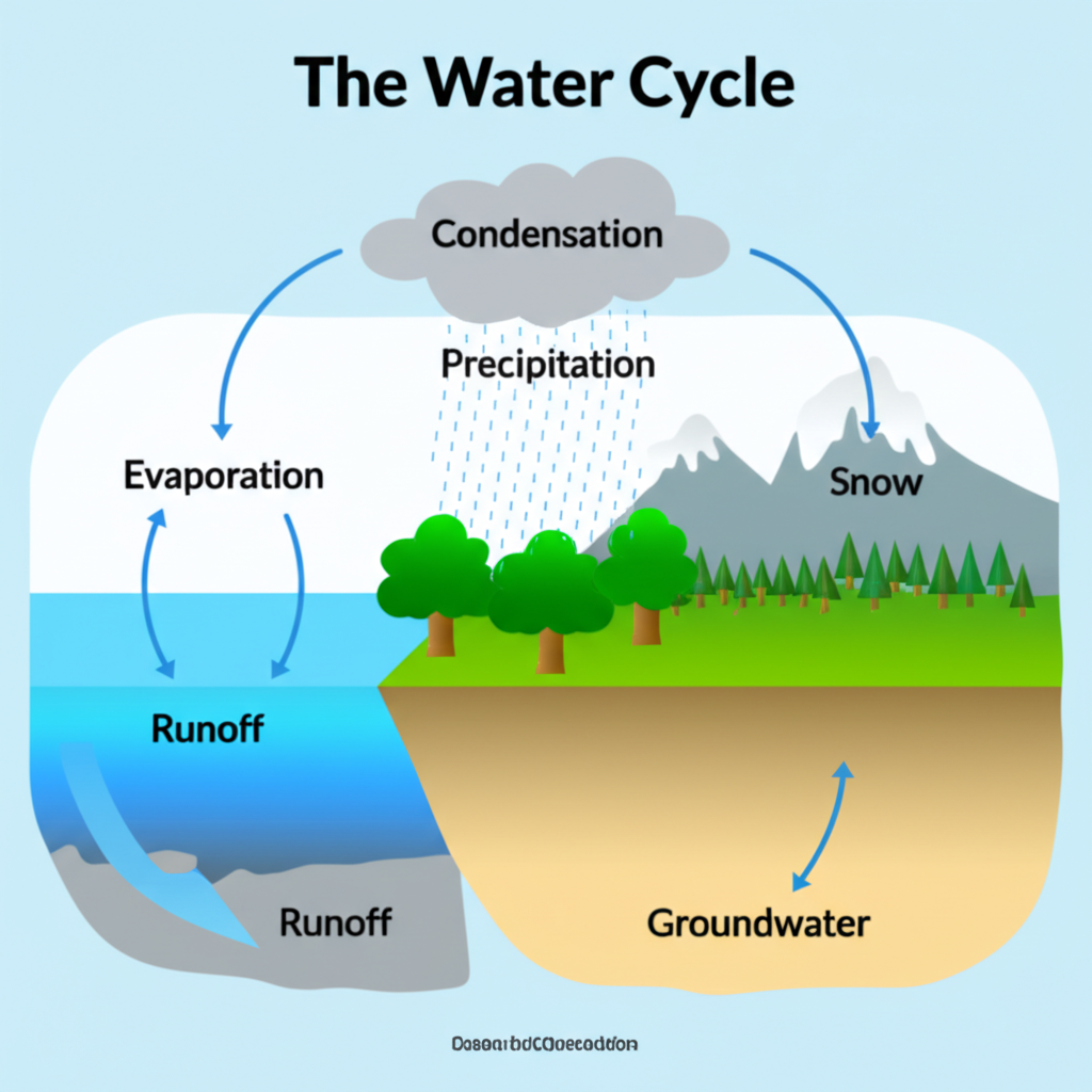
Liquid water turns into vapor, rising into the atmosphere (driven by solar energy)
Plants release water vapor through their leaves into the atmosphere
Water vapor cools and changes back into liquid droplets, forming clouds
Water falls back to Earth as rain, snow, sleet, or hail
Water flows over land surface, collecting in streams and rivers
Water soaks into the ground, becoming groundwater stored in aquifers
Rivers & Streams
- Source: Origin of a river, often in mountains or springs
- Tributaries: Smaller streams that flow into a larger river
- Confluence: Where two rivers join
- Mouth: Where a river empties into a lake or ocean
- Watershed: The entire area of land that drains into a specific river system
Glaciers
Glaciers form where snow accumulation exceeds melting over many years, compressing into dense ice. They are powerful erosional agents that create distinctive landforms:
- Erosional: Cirques, arêtes, horns, U-shaped valleys
- Depositional: Moraines (ridges of till), drumlins (teardrop hills), erratics (boulders transported far)
Oceans
Oceans cover 70%+ of Earth's surface and are critical to global climate:
- Currents: Driven by wind, temperature, salinity, and the Coriolis effect — distribute heat globally
- Tides: Rise and fall of sea levels from gravitational pull of Moon and Sun
- Wave erosion: Creates sea cliffs, sea arches, sea stacks, caves
- Coastal deposition: Beaches, barrier islands, sand spits, lagoons
6Biomes & Ecosystems
A biome is a large geographical region characterized by specific climate, plant life, and animal life. Click on the map below to explore each biome's characteristics.
World Biomes — Interactive Map
Click a biome on the map or legend to explore its characteristics
Click a biome region on the map or a label above to see details
Factors That Determine Biomes
Distance from equator — affects temperature and sunlight
Higher altitude = colder temperatures and different vegetation
Large bodies of water moderate temperature extremes
Can warm or cool coastal regions, affecting precipitation
Distribute moisture and influence regional temperature
Ecosystems
An ecosystem is a more specific community of living organisms (biotic factors — plants, animals) interacting with their non-living environment (abiotic factors — soil, water, sunlight, temperature). A biome is a collection of similar ecosystems across a large area.
7Maps & Geographic Tools
Topographic Maps
- Contour lines connect points of equal elevation above sea level
- Closely spaced lines = steep slope; widely spaced = gentle slope
- Contour lines never cross each other
- V-shapes in contour lines point upstream in a river valley
Latitude & Longitude
Measures north/south of the equator (0°). Lines run east-west, parallel to each other. 0° to 90°N or 90°S.
Measures east/west of the Prime Meridian (0°). Lines run north-south, converging at poles. 0° to 180°E or 180°W.
Map Projections
Good for navigation (straight lines), but distorts size near poles (Greenland looks huge)
Compromise projection — minimizes distortion in area, shape, and distance; common for world maps
Accurately shows relative sizes of landmasses but distorts their shapes
Modern Tools
- GIS (Geographic Information Systems): Computer systems that capture, store, analyze, and present geographical data
- Remote Sensing: Gathering information using satellites or aircraft — satellite imagery, aerial photography
8Memory Aids
"Crunchy Mangoes Often Include..."
Crust, Mantle, Outer Core, Inner Core
"C = Colliding, D = Dividing, T = Twisting"
Convergent (collide/crunch), Divergent (divide/drift apart), Transform (twist/slide)
"Every Cloud Produces Rain Inside"
Evaporation, Condensation, Precipitation, Runoff, Infiltration
"My Chemical Book"
Mechanical, Chemical, Biological
"Tigers Don't Generally Take Big Trips Alone"
Tropical Rainforest, Desert, Grassland, Temperate Forest, Boreal Forest (Taiga), Tundra, Aquatic
Quick Revision Summary
- Physical geography studies Earth's natural features — lithosphere, atmosphere, hydrosphere, biosphere.
- Earth has four main layers: crust, mantle, outer core (liquid), inner core (solid).
- Plate tectonics: Earth's crust is divided into moving plates driven by mantle convection.
- Convergent boundaries → mountains, subduction, volcanoes (Himalayas, Andes).
- Divergent boundaries → new crust, mid-ocean ridges, rift valleys.
- Transform boundaries → earthquakes (San Andreas Fault).
- Ring of Fire: 75% of active volcanoes, 90% of earthquakes around the Pacific.
- Weathering breaks rock in place (mechanical, chemical, biological).
- Erosion transports material by water, wind, ice, or gravity.
- Rivers create V-shaped valleys, meanders, oxbow lakes, deltas.
- Glaciers create U-shaped valleys, cirques, arêtes, horns, moraines.
- Water cycle: evaporation → condensation → precipitation → runoff/infiltration.
- Biomes are defined by climate, temperature, and precipitation (7 major types).
- Contour lines on topographic maps show elevation — close together = steep.
- Climate is long-term patterns; weather is short-term conditions.
Frequently Asked Questions
What is the difference between weathering and erosion?
Weathering breaks down rock in place — it does not involve movement. Erosion is the process of transporting weathered material from one location to another by agents like water, wind, ice, or gravity. Think of it as: weathering = breaking, erosion = moving.
What are the three types of plate boundaries?
Convergent (plates collide — forming mountains, subduction zones, volcanoes), Divergent (plates separate — forming mid-ocean ridges, rift valleys), and Transform (plates slide past each other — causing earthquakes, like the San Andreas Fault).
What is the difference between weather and climate?
Weather is the short-term atmospheric condition at a specific time and place (today's temperature, rain, wind). Climate is the long-term average of weather patterns in a region over 30+ years. "Climate is what you expect; weather is what you get."
Why is the Ring of Fire so geologically active?
The Ring of Fire is a horseshoe-shaped zone around the Pacific Ocean basin where multiple tectonic plates meet. It has numerous subduction zones where oceanic plates dive beneath continental plates, creating intense volcanic and earthquake activity — about 75% of the world's active volcanoes and 90% of earthquakes occur here.
What factors determine which biome exists in a region?
The main factors are: latitude (distance from the equator affects temperature), elevation (higher = colder), proximity to large bodies of water (moderates temperature), ocean currents (can warm or cool coasts), and prevailing wind patterns (distribute moisture). Temperature and precipitation are the two most important factors.
Practice Quiz
1. Which layer of Earth is responsible for generating the planet's magnetic field?
2. The process where one tectonic plate slides beneath another is called:
3. Which type of weathering involves the chemical alteration of rock minerals, such as the formation of rust?
4. A U-shaped valley is a distinctive landform primarily created by the erosional action of:
5. What is the term for water vapor changing into liquid water droplets, forming clouds?
6. Which biome is characterized by permafrost, extremely cold temperatures, and low-growing plants like mosses and lichens?
7. On a topographic map, what do closely spaced contour lines indicate?
8. The point on Earth's surface directly above where an earthquake originates is called the:
9. Which of the following is an example of a depositional landform?
10. What is the main difference between weather and climate?
Study Tips for Physical Geography
- Draw and label diagrams — sketch Earth's layers, plate boundaries, the water cycle from memory.
- Use real-world examples — connect concepts to actual places (Himalayas = convergent, Grand Canyon = river erosion).
- Compare and contrast — V-shaped vs. U-shaped valleys, weather vs. climate, mechanical vs. chemical weathering.
- Practice with maps — read topographic maps, identify contour patterns, use latitude/longitude coordinates.
- Make flashcards for key terms — physical geography has many vocabulary terms that are essential to know.